
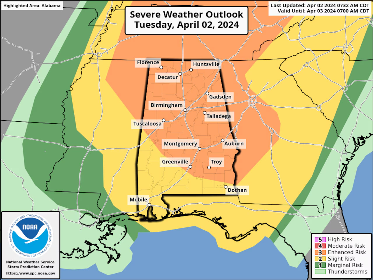

기상캐스터들에 따르면, 오늘(2일) 오후에는 앨라배마 전역에 악천후가 예상된다.
폭풍은 오늘 오후 늦게 앨라배마에 도착할 것으로 예상되며, 밤새도록 지속될 전망이다.
일부는 강하고 큰 우박을 동반하는 토네이도가 발생할 수 있으며, 특히 늦은 밤에 가능성이 높다. 앨라배마 북부 지역에서는 2등급 토네이도가 발생할 수 있다고 기상청은 주의를 당부했다.
또한 최대 시속 70마일의 돌풍 및 폭우가 모두 발생할 수 있다고 기상청은 예보했다.
[6:43 AM] Severe thunderstorms capable of producing several tornadoes (some strong), damaging winds (up to 70-80 MPH) and large hail are expected to begin early this afternoon in northwest AL before spreading eastward. Have multiple ways to receive weather information. #HUNwx pic.twitter.com/3zFRsLpq8q
— NWS Huntsville (@NWSHuntsville) April 2, 2024
특히 앨라배마 중동부에서 북부지역 일대에는 오늘 3등급 악천후가 예상되는데, 이는 심각한 폭풍을 의미한다.
Update @ 8 am: Confidence is increasing of damaging winds up to 70 mph, large hail, and tornadoes possible through the afternoon and overnight. There is a lot of wind available for these storms to use. Use this time now to go through your safety plans! pic.twitter.com/b01ez6TscZ
— NWS Birmingham (@NWSBirmingham) April 2, 2024
국립기상청은 앨라배마 주민들에게 밤새 악천후 경보를 받을 수 있는 여러가지 방법을 마련하라고 경고했다.
폭풍우는 북서지역은 오후 2시부터, 중부지역은 오후 5시, 북동지역은 오후 8시경에 도착할 전망이다.


